
Mindanao
From Wikipedia, the free encyclopedia
/mɪndəˈnaʊ/ min-də-NOW) (Tagalog: Kamindanawan) is the second largest and southernmost major island in the Philippines. It is also the name of one of the three island groups in the country (the other two being Luzon and the Visayas), consisting of the island of Mindanao and smaller surrounding islands. Davao City
is the largest city in Mindanao. As of the 2010 census, the island's
population itself is 20,281,545 people, while the Mindanao island group
has 21,968,174 inhabitants.[1]
Parts of south-western Mindanao, particularly Maguindanao Province, Lanao del Sur, Sulu, and Tawi-tawi provinces (part of the Autonomous Region of Muslim Mindanao (ARMM)), are home to a sizeable Muslim population, making the island the only area of the Philippines with significant Muslim presence. Due to widespread poverty and religious differences, the island has seen a communist insurgency as well as armed Moro separatist movements.
Mindanao is considered the agricultural basin of the Philippines. Eight of the top 10 agri-commodities exported from the Philippines come from here.[2]
 Mindanao is named after the Maguindanaons who constituted the largest Sultanate historically, and evidence from maps made during the 17th and 18th centuries suggests that the name was used to refer to the island
by the powerful natives at the time. Evidence of human occupation dates
back tens of thousands of years. In prehistoric times the Negrito people arrived. Sometime around 1500 BC Austronesian peoples spread throughout the Philippines and far beyond. Native people of the Maluku Islands refer the island as Maluku Besar (Great Moluccas).
Mindanao is named after the Maguindanaons who constituted the largest Sultanate historically, and evidence from maps made during the 17th and 18th centuries suggests that the name was used to refer to the island
by the powerful natives at the time. Evidence of human occupation dates
back tens of thousands of years. In prehistoric times the Negrito people arrived. Sometime around 1500 BC Austronesian peoples spread throughout the Philippines and far beyond. Native people of the Maluku Islands refer the island as Maluku Besar (Great Moluccas).
Mindanao Island is also a sacred home of Raja Bantogen the Meranaw largest non-Muslim and Subanon Tribe; the aborigine of the Zamboanga Peninsula’s Zamboanga del Norte, Zamboanga del Sur, Zamboanga Sibugay, Island of Basilan, and northern provinces of Misamis Occidental, Lanao del Norte, and Misamis Oriental.
Subanon is believed to have established in Mindanao Island during the Neolithic Era, or New Stone Age where the period in the development of human technology taken place beginning 10,000 BC according to the ASPRO chronology (between 4,500 and 2,000 BC).[3] The evidence of old stone tools in Zamboanga del Norte may indicate a late Neolithic presence. Burial jars, both earthen and glazed, as well as Chinese celadons, have been found in caves, together with shell bracelets, beads, and gold ornaments. Many of the ceramic wares are from the Yuan and Ming periods. Evidently, there was a long history of trade between the Subanon and the Chinese long before the latter’s contact with Islam.
Islam first spread to the region during the 13th century through Arab traders from present-day Malaysia and Indonesia. Prior to this contact, the inhabitants of the area were primarily animists living in small autonomous communities.[4] Most of the indigenous population of Tausug, Maranao and Maguindanaon are quickly converted into Islam except the elusive Subanon, Talaandig, Higaonon and some other small tribes who resisted and avoided contact with the Arabian Islamic missionaries.
The first mosque in the Philippines was built in the mid 14th century in the town of Simunul.[4] The Philippine sultanates of Sulu and Maguindanao were subsequently in the 15th and 16th centuries, respectively. In the late 16th to early 17th centuries, the first contact with Spain occurred. By this time, Islam was well established in Mindanao and had started influencing groups on big islands of Visayas like Cebu and as far north as Bohol and present-day Manila on the island of Luzon.[4]
Upon the Spaniards' arrival to the Philippines, they were dismayed to find such a strong Muslim presence on the island, having just expelled the Moors from Spain after centuries of fighting under the Reconquista. In fact, the name Moros (the Spanish word for "Moors") was given to the Muslim inhabitants by the Spanish.[4] Caesarea Caroli was the name given by Villalobos to the island of Mindanao when he reached the sea near it. This was named after the Charles V of the Holy Roman Empire (and I of Spain).
After the Spanish-American War the Americans fought numerous battles against the Moro. At the start of World War II, Japanese forces defeated Gen. William F. Sharp's forces, including Gen. Guy O. Fort's 81st Division, after a battle which started at Malabang, Lanao, on 29 April 1942, and ended near Ganassi, Lanao, on 10 May 1942.[5] However, guerrilla forces were active until liberation at the conclusion of the Battle of Mindanao.
The region is home to most of the country's Muslim or Moro populations, composed of many ethnic groups such as the Maranao and the Tausug, Maguindanaon the Banguingui (users of the vinta), as well as the collective group of indigenous tribes known as the Lumad.
At the beginning of the 20th century, the Moro and Lumads controlled an area which now covers 17 of Mindanao’s 24 provinces, but by the 1980 census, they constituted less than 6% of the population of Mindanao and Sulu. Heavy migration to Mindanao of Luzon and Visayans, spurred by government-sponsored resettlement programmes, turned the indigenous Lumads and Moros into minorities.[6]
The island group of Mindanao encompasses Mindanao island itself and the Sulu Archipelago to the southwest. The island group is divided into six regions, which are further subdivided into 26 provinces.
Paralleling the east coast, from Bilas Point in Surigao del Norte to Cape Agustin in southeast Davao, is a range of complex mountains known in their northern portion as the Diwata Mountains and Mount Makaturing of Butig. This range is low and rolling in its central portion. A proposed road connecting Bislig on the east coast with the Agusan River would pass through a 16 kilometres (9.9 mi) broad saddle across the mountains at a maximum elevation of less than 250 metres (820 ft), while the existing east-west road from Lianga, 30 miles (48 km) north of Bislig, reaches a maximum elevation of only 450 metres (1,480 ft). The Diwata Mountains, north of these low points, are considerably higher and more rugged, reaching an elevation of 2,012 metres (6,601 ft) in Mount Hilong-Hilong, 17 miles (27 km) along the eastern portion of Cabadbaran City. The southern portion of this east coast range is broader and even more rugged than the northern section. In eastern Davao, several peaks rise above 2,600 metres (8,500 ft) and one mountain rises to 2,910 metres (9,550 ft).
 The east-facing coastal regions of Davao and Surigao del Sur are
marked by a series of small coastal lowlands separated from each other
by rugged forelands which extend to the water’s edge. Offshore are
numerous coral reefs and tiny islets.
This remote and forbidding coast is made doubly difficult to access
during the months from October to March by the heavy surf driven before
the northeast trade winds. A few miles offshore is found the Mindanao or
Philippine Deep.
This ocean trench, reaching measured depths of 37,400 feet (11,400 m),
marks one of the greatest depths known on the earth’s surface.
The east-facing coastal regions of Davao and Surigao del Sur are
marked by a series of small coastal lowlands separated from each other
by rugged forelands which extend to the water’s edge. Offshore are
numerous coral reefs and tiny islets.
This remote and forbidding coast is made doubly difficult to access
during the months from October to March by the heavy surf driven before
the northeast trade winds. A few miles offshore is found the Mindanao or
Philippine Deep.
This ocean trench, reaching measured depths of 37,400 feet (11,400 m),
marks one of the greatest depths known on the earth’s surface.
A second north-south range extends along the western borders of the Agusan (del Norte and del Sur) and Davao provinces from Camiguin Island in the north to Tinaca Point in the south. This range is mainly structural in origin, but it also contains at least three active volcano peaks. In the central and northern portions of this range, there are several peaks between 2,000 and 2,600 metres (6,600 and 8,500 ft), and here the belt of mountains is about 30 miles (48 km) across. West of Davao City are two inactive volcanoes: Mount Talomo at 2,893 metres (9,491 ft) and Mount Apo at 2,954 metres (9,692 ft), which is the highest point in the Philippines and dominates the skyline. South of Mount Apo, this central mountain belt is somewhat lower than it is to the north, with peaks averaging only 1,100 to 1,800 metres (3,600 to 5,900 ft).
In Western Mindanao, a range of complex structural mountains forms the long, hand-like Zamboanga Peninsula. These mountains, reaching heights of only 1,200 meters (3,900 feet), are not as high as the other structural belts in Mindanao. In addition, there are several places in the Zamboanga Mountains where small inter-mountain basins have been created, with some potential for future agricultural development. The northeastern end of this range is marked by the twin peaks of the now extinct volcano, Mount Malindang, which rise behind Ozamis City to a height of 2,425 metres (7,956 ft). Mount Dapia is the highest mountain in the Zamboanga Peninsula, reaching a height of 2,617 meters (8,586 feet). Meanwhile, Batorampon Point is the highest mountain of the southernmost end of the peninsula, reaching a height of only 1,335 meters (4,380 feet); it is located in the boundary of Zamboanga City.
A series of volcanic mountains is found near Lake Lanao in a broad arc through Lanao del Sur, northern Cotabato and western Bukidnon provinces. At least six of the twenty odd peaks in this area are active and several are very impressive as they stand in semi-isolation. The Butig Peaks, with their four crater lakes, are easily seen from Cotabato. Mount Ragang, an active volcano cone reaching 2,815 metres (9,236 ft), is the most isolated, while the greatest height is reached by Mount Kitanglad at 2,889 metres (9,478 ft).
 In southwestern Cotabato,
still another range of volcanic mountains is found, this time
paralleling the coast. These mountains have a maximum extent of 110
miles (180 km) from northwest to southeast and measure some 30 miles
(48 km) across. One of the well-known mountains here is Mount Parker, whose almost circular crater lake measures a mile and a quarter in diameter and lies 300 metres (980 ft) below its 2,040 metres (6,690 ft) summit. Mount Matutum is a protected area and is considered as one of the major landmarks of South Cotabato Province.
In southwestern Cotabato,
still another range of volcanic mountains is found, this time
paralleling the coast. These mountains have a maximum extent of 110
miles (180 km) from northwest to southeast and measure some 30 miles
(48 km) across. One of the well-known mountains here is Mount Parker, whose almost circular crater lake measures a mile and a quarter in diameter and lies 300 metres (980 ft) below its 2,040 metres (6,690 ft) summit. Mount Matutum is a protected area and is considered as one of the major landmarks of South Cotabato Province.
A second important physiographic division of Mindanao is the series of upland plateaus in Bukidnon and Lanao del Sur provinces. These plateaus are rather extensive and almost surround several volcanoes in this area. The plateaus are made up of basaltic lava flows interbedded with ash and volcanic tuff. Near their edges, the plateaus are cut by deep canyons, and at several points spectacular waterfalls drop to the narrow coastal plain. These falls hold considerable promise for development of hydroelectric energy. Indeed, one such site at Maria Cristina Falls has already become a major producer. Because the rolling plateaus lie at an elevation averaging 700 meters above sea level, they offer relief from the often oppressive heat of the coastal lowlands. Lake Lanao occupies the major portion of one such plateau in Lanao del Sur. This largest lake on Mindanao and second in the country is roughly triangular in shape with an 18-mile (29 km)-long base. Having a surface at 780 meters above sea level, and being rimmed on the east, south and west by series of peaks reaching 2,300 meters, the lake provides a scenic grandeur and pleasant temperature seldom equaled in the country.[citation needed] Marawi City, at the northern tip of the lake, is bisected by the Agus River, which feeds the Maria Cristina Falls.
Another of Mindanao’s spectacular waterfall sites is located in Malabang, 15 miles (24 km) south of Lake Lanao. Here the Jose Abad Santos Falls present one of the nation’s scenic wonders at the gateway to a 200-hectare national park development.
The Limunsudan Falls, with an approximate height of 800 ft (240 m), is the highest waterfalls in the Philippines; it is located at Iligan City.
The Rio Grande de Mindanao and its main tributaries, the Catisan and the Pulangi, form a valley with a maximum length of 120 miles (190 km) and a width which varies from 12 miles (19 km) at the river mouth to about 60 miles (97 km) in central Cotabato. The southern extensions of this Cotabato Valley extend uninterrupted across a 350 metres (1,150 ft) watershed from Illana Bay on the northwest to Sarangani Bay on the southeast.
Other lowlands of a coastal nature are to be found in various parts of Mindanao. Many of these are tiny isolated pockets, as along the northwest coast of Zamboanga. In other areas such as the Davao Plain, these coastal lowlands are as much as 16 kilometres (9.9 mi) wide and several times that length.
From Dipolog City eastward along the northern coast of Mindanao almost to Butuan City extends a rolling coastal plain of varying width. In Misamis Occidental, the now dormant Mount Malindang has created a lowland averaging 13 kilometres (8.1 mi) in width. Shallow Panquil Bay divides this province from Lanao del Norte, and is bordered by low-lying, poorly drained lowlands and extensive mangroves. In Misamis Oriental, the plain is narrower and in places almost pinched out by rugged forelands which reach to the sea. East of Cagayan de Oro, a rugged peninsula extends well into the Mindanao Sea.
 Mindanao is the most culturally diverse island in the Philippines where people of different languages, tribes and races meet. As the Moro and Lumad alliance provided an effective resistance to Spanish
rule, Mindanao became a melting pot of different cultures, it creates a
more distinct culture which is not present in other island groups in
the country. Mindanao has been the seat of two great Sultanates namely
the Sultanate of Sulu and the Sultanate of Maguindanao along with the most hispanized city in Asia, strategic Zamboanga City. A considerable number of Buddhist and Taoist temples and the indigenous tribes known as Lumad people which makes it more diverse.
Mindanao is the most culturally diverse island in the Philippines where people of different languages, tribes and races meet. As the Moro and Lumad alliance provided an effective resistance to Spanish
rule, Mindanao became a melting pot of different cultures, it creates a
more distinct culture which is not present in other island groups in
the country. Mindanao has been the seat of two great Sultanates namely
the Sultanate of Sulu and the Sultanate of Maguindanao along with the most hispanized city in Asia, strategic Zamboanga City. A considerable number of Buddhist and Taoist temples and the indigenous tribes known as Lumad people which makes it more diverse.
Due to the continuous re settlement programs[8] by the Central Government in Manila, Cebuano is spoken by the majority of people in Mindanao. Cebuano is generally the first language in most regions, except for the Bangsamoro areas on the west coast and among the Lumads. Tagalog is also widely spoken among the people. Hiligaynon or Ilonggo is widely spoken in South Cotabato and a large part of Cotabato Province. English is also widely spoken.
The Spanish-based creole, Zamboangueño Chavacano is the main language spoken in Zamboanga City and Basilan, scatteredly spoken around Zamboanga del Sur, Zamboanga del Norte, Zamboanga Sibugay, parts of Sulu and Tawi-Tawi. The dialect Zamboangueño Chavacano is one of the six dialects of Chavacano (whose native speakers are known as the Latino Zamboangueño). other spoken dialects of Chavacano Language are the following: Cotabateñ in Cotabato City and Castellano Abakay in Davao Region.
Settlers now form the majority, with 63% of the population; Moro are 32% of the population; 5% are Lumads and most of them intermarried with the Settlers. The native Maguindanaon and other native Moro or Lumad groups of Mindanao have a culture that is different from the main culture of the Philippines.
 After 70 Decades of Settler biased land tenure laws,[8] changing of traditional and cultural places to Roman Catholic Saints names and even names of a General bringing in Settlers,[12] putting the crucifix on top of Mindanao Mountains, formation of religious based Settler militia called Ilaga led by officers of the Philippine Constabulary, connivance of Philippine Armed Forces with the Ilaga as a tool for counter insurgency resulted in full blown Insurgency
led mostly by the Moro, Lumads and few impoverished Settlers. Cycles of
displacement that have affected Central Mindanao for several decades
have peaked during the first decade of the 20th Century.
After 70 Decades of Settler biased land tenure laws,[8] changing of traditional and cultural places to Roman Catholic Saints names and even names of a General bringing in Settlers,[12] putting the crucifix on top of Mindanao Mountains, formation of religious based Settler militia called Ilaga led by officers of the Philippine Constabulary, connivance of Philippine Armed Forces with the Ilaga as a tool for counter insurgency resulted in full blown Insurgency
led mostly by the Moro, Lumads and few impoverished Settlers. Cycles of
displacement that have affected Central Mindanao for several decades
have peaked during the first decade of the 20th Century.
After decades of “low intensity conflict” in Maguindanao between 1976 and 2000, President Estrada’s “All Out War” strategy declared in 2000 led to the displacement of more than 930,000 individuals. The decade that followed has been marked by a cycle of violence and resumption of peace talks between the government and the Moro Islamic Liberation Front that sought to establish an independent Islamic state in Maguindanao. The fighting led to several periods of mass population displacement at the very latest even until the term of President Gloria Macapagal Arroyo displacing another 150,000 individuals mostly of Moro & Lumad communities[13]
Between 2000 and 2010, four out of ten households (41%) reported having experienced displacement: 29% reported displacement caused by armed groups’ movements, 9% identified ridos (blood feuds), and 9% identified other causes, such as economic displacement (3%) or natural disasters (2%). Armed groups’ movements were by far the most frequent cause of displacement and also the most damageable. Some provinces were more affected than others, mostly of the Moro as they are the most active in resistance to what they perceived to be an extension of Spanish colonialism now perpetuated by the hands of the Philippine Government. Areas that suffered most damage and displacement are Maguindanao (82%), Lanao del Norte (48%) and Lanao del Sur (47%). Other forms of violence have also been prevalent. For example, in Maguindanao, 45% of the total population reported the destruction of their home. Other forms of violence reported in that province include the destruction of goods (37%), being attacked by someone with a weapon (20%), witness looting (32%), and witness killing (16%).[14]
The island group of Mindanao is an arbitrary grouping of islands in the Southern Philippines which encompasses six administrative regions.[15] These regions are further subdivided into 26 provinces,
of which only five are not on Mindanao island itself. Some of the areas
are semi-autonomous Muslim areas. The island group includes the Sulu Archipelago to the southwest, which consists of the major islands of Basilan, Jolo, and Tawitawi, plus outlying islands in other areas such as Camiguin, Dinagat, Siargao, Samal.
The six regions are:
Mindanao is composed of 26 provinces,
each headed by a governor. A governor is elected by popular vote and
can serve a maximum of three terms consisting of three years each.
As for representation in the Philippine Congress, Mindanao is represented by 46 congressmen elected in the same manner as the governors.
 Autonomous Region in Muslim Mindanao (ARMM) or also known as Bangsamoro
is the region, located in the Mindanao island group of the Philippines,
that is composed of predominantly Muslim provinces. The regional center
is Cotabato City although it is not administratively part of the ARMM. Its provinces are:
Autonomous Region in Muslim Mindanao (ARMM) or also known as Bangsamoro
is the region, located in the Mindanao island group of the Philippines,
that is composed of predominantly Muslim provinces. The regional center
is Cotabato City although it is not administratively part of the ARMM. Its provinces are:


Parts of south-western Mindanao, particularly Maguindanao Province, Lanao del Sur, Sulu, and Tawi-tawi provinces (part of the Autonomous Region of Muslim Mindanao (ARMM)), are home to a sizeable Muslim population, making the island the only area of the Philippines with significant Muslim presence. Due to widespread poverty and religious differences, the island has seen a communist insurgency as well as armed Moro separatist movements.
Mindanao is considered the agricultural basin of the Philippines. Eight of the top 10 agri-commodities exported from the Philippines come from here.[2]
Contents
History

An old Spanish map of Mindanao island.
Mindanao Island is also a sacred home of Raja Bantogen the Meranaw largest non-Muslim and Subanon Tribe; the aborigine of the Zamboanga Peninsula’s Zamboanga del Norte, Zamboanga del Sur, Zamboanga Sibugay, Island of Basilan, and northern provinces of Misamis Occidental, Lanao del Norte, and Misamis Oriental.
Subanon is believed to have established in Mindanao Island during the Neolithic Era, or New Stone Age where the period in the development of human technology taken place beginning 10,000 BC according to the ASPRO chronology (between 4,500 and 2,000 BC).[3] The evidence of old stone tools in Zamboanga del Norte may indicate a late Neolithic presence. Burial jars, both earthen and glazed, as well as Chinese celadons, have been found in caves, together with shell bracelets, beads, and gold ornaments. Many of the ceramic wares are from the Yuan and Ming periods. Evidently, there was a long history of trade between the Subanon and the Chinese long before the latter’s contact with Islam.
Islam first spread to the region during the 13th century through Arab traders from present-day Malaysia and Indonesia. Prior to this contact, the inhabitants of the area were primarily animists living in small autonomous communities.[4] Most of the indigenous population of Tausug, Maranao and Maguindanaon are quickly converted into Islam except the elusive Subanon, Talaandig, Higaonon and some other small tribes who resisted and avoided contact with the Arabian Islamic missionaries.
The first mosque in the Philippines was built in the mid 14th century in the town of Simunul.[4] The Philippine sultanates of Sulu and Maguindanao were subsequently in the 15th and 16th centuries, respectively. In the late 16th to early 17th centuries, the first contact with Spain occurred. By this time, Islam was well established in Mindanao and had started influencing groups on big islands of Visayas like Cebu and as far north as Bohol and present-day Manila on the island of Luzon.[4]
Upon the Spaniards' arrival to the Philippines, they were dismayed to find such a strong Muslim presence on the island, having just expelled the Moors from Spain after centuries of fighting under the Reconquista. In fact, the name Moros (the Spanish word for "Moors") was given to the Muslim inhabitants by the Spanish.[4] Caesarea Caroli was the name given by Villalobos to the island of Mindanao when he reached the sea near it. This was named after the Charles V of the Holy Roman Empire (and I of Spain).
After the Spanish-American War the Americans fought numerous battles against the Moro. At the start of World War II, Japanese forces defeated Gen. William F. Sharp's forces, including Gen. Guy O. Fort's 81st Division, after a battle which started at Malabang, Lanao, on 29 April 1942, and ended near Ganassi, Lanao, on 10 May 1942.[5] However, guerrilla forces were active until liberation at the conclusion of the Battle of Mindanao.
The region is home to most of the country's Muslim or Moro populations, composed of many ethnic groups such as the Maranao and the Tausug, Maguindanaon the Banguingui (users of the vinta), as well as the collective group of indigenous tribes known as the Lumad.
At the beginning of the 20th century, the Moro and Lumads controlled an area which now covers 17 of Mindanao’s 24 provinces, but by the 1980 census, they constituted less than 6% of the population of Mindanao and Sulu. Heavy migration to Mindanao of Luzon and Visayans, spurred by government-sponsored resettlement programmes, turned the indigenous Lumads and Moros into minorities.[6]
Geography
Mindanao is the second largest island in the Philippines at 104,630 square kilometers, and is the eighth most populous island in the world. The island of Mindanao is larger than 125 countries worldwide, including the Netherlands, Austria, Portugal, Czech Republic, Hungary, and Ireland. The island is mountainous, and is home to Mount Apo, the highest mountain in the country. Mindanao is surrounded by 4 seas: the Sulu Sea to the west,[7] the Philippine Sea to the east, and the Celebes Sea to the south, and the Mindanao Sea to the north. Of all the islands of the Philippines, Mindanao shows the greatest variety of physiographic development. High, rugged, faulted mountains; almost isolated volcanic peaks; high rolling plateaus; and broad, level, swampy plains are found there.The island group of Mindanao encompasses Mindanao island itself and the Sulu Archipelago to the southwest. The island group is divided into six regions, which are further subdivided into 26 provinces.
Mountains and plateaus
The mountains of Mindanao can be conveniently grouped into ten ranges, including both complex structural mountains and volcanoes. The structural mountains on the extreme eastern and western portions of the island show broad exposures of Mesozoic rock with ultrabasic rocks at the surface in many places along the east coast. Other parts of the island consists mainly of Cenozoic and Quaternary volcanic or sedimentary rocks.Paralleling the east coast, from Bilas Point in Surigao del Norte to Cape Agustin in southeast Davao, is a range of complex mountains known in their northern portion as the Diwata Mountains and Mount Makaturing of Butig. This range is low and rolling in its central portion. A proposed road connecting Bislig on the east coast with the Agusan River would pass through a 16 kilometres (9.9 mi) broad saddle across the mountains at a maximum elevation of less than 250 metres (820 ft), while the existing east-west road from Lianga, 30 miles (48 km) north of Bislig, reaches a maximum elevation of only 450 metres (1,480 ft). The Diwata Mountains, north of these low points, are considerably higher and more rugged, reaching an elevation of 2,012 metres (6,601 ft) in Mount Hilong-Hilong, 17 miles (27 km) along the eastern portion of Cabadbaran City. The southern portion of this east coast range is broader and even more rugged than the northern section. In eastern Davao, several peaks rise above 2,600 metres (8,500 ft) and one mountain rises to 2,910 metres (9,550 ft).

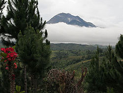
Mt. Apo, the highest peak in the Philippines.
A second north-south range extends along the western borders of the Agusan (del Norte and del Sur) and Davao provinces from Camiguin Island in the north to Tinaca Point in the south. This range is mainly structural in origin, but it also contains at least three active volcano peaks. In the central and northern portions of this range, there are several peaks between 2,000 and 2,600 metres (6,600 and 8,500 ft), and here the belt of mountains is about 30 miles (48 km) across. West of Davao City are two inactive volcanoes: Mount Talomo at 2,893 metres (9,491 ft) and Mount Apo at 2,954 metres (9,692 ft), which is the highest point in the Philippines and dominates the skyline. South of Mount Apo, this central mountain belt is somewhat lower than it is to the north, with peaks averaging only 1,100 to 1,800 metres (3,600 to 5,900 ft).
In Western Mindanao, a range of complex structural mountains forms the long, hand-like Zamboanga Peninsula. These mountains, reaching heights of only 1,200 meters (3,900 feet), are not as high as the other structural belts in Mindanao. In addition, there are several places in the Zamboanga Mountains where small inter-mountain basins have been created, with some potential for future agricultural development. The northeastern end of this range is marked by the twin peaks of the now extinct volcano, Mount Malindang, which rise behind Ozamis City to a height of 2,425 metres (7,956 ft). Mount Dapia is the highest mountain in the Zamboanga Peninsula, reaching a height of 2,617 meters (8,586 feet). Meanwhile, Batorampon Point is the highest mountain of the southernmost end of the peninsula, reaching a height of only 1,335 meters (4,380 feet); it is located in the boundary of Zamboanga City.
A series of volcanic mountains is found near Lake Lanao in a broad arc through Lanao del Sur, northern Cotabato and western Bukidnon provinces. At least six of the twenty odd peaks in this area are active and several are very impressive as they stand in semi-isolation. The Butig Peaks, with their four crater lakes, are easily seen from Cotabato. Mount Ragang, an active volcano cone reaching 2,815 metres (9,236 ft), is the most isolated, while the greatest height is reached by Mount Kitanglad at 2,889 metres (9,478 ft).

Mindanao coast
A second important physiographic division of Mindanao is the series of upland plateaus in Bukidnon and Lanao del Sur provinces. These plateaus are rather extensive and almost surround several volcanoes in this area. The plateaus are made up of basaltic lava flows interbedded with ash and volcanic tuff. Near their edges, the plateaus are cut by deep canyons, and at several points spectacular waterfalls drop to the narrow coastal plain. These falls hold considerable promise for development of hydroelectric energy. Indeed, one such site at Maria Cristina Falls has already become a major producer. Because the rolling plateaus lie at an elevation averaging 700 meters above sea level, they offer relief from the often oppressive heat of the coastal lowlands. Lake Lanao occupies the major portion of one such plateau in Lanao del Sur. This largest lake on Mindanao and second in the country is roughly triangular in shape with an 18-mile (29 km)-long base. Having a surface at 780 meters above sea level, and being rimmed on the east, south and west by series of peaks reaching 2,300 meters, the lake provides a scenic grandeur and pleasant temperature seldom equaled in the country.[citation needed] Marawi City, at the northern tip of the lake, is bisected by the Agus River, which feeds the Maria Cristina Falls.
Another of Mindanao’s spectacular waterfall sites is located in Malabang, 15 miles (24 km) south of Lake Lanao. Here the Jose Abad Santos Falls present one of the nation’s scenic wonders at the gateway to a 200-hectare national park development.
The Limunsudan Falls, with an approximate height of 800 ft (240 m), is the highest waterfalls in the Philippines; it is located at Iligan City.
Plains
Mindanao contains two large inland lowland areas, the valleys of the Agusan and Mindanao rivers in Agusan and Cotabato Provinces, respectively. There is some indication that the Agusan Valley occupies a broad syncline between the central mountains and the east-coast mountains. This valley measures 110 miles (180 km) from south to north and varies from 20 to 30 miles (32 to 48 km) in width. 35 miles (56 km) north of the head of Davao Gulf lies the watershed between the Agusan and the tributaries of the Libuganon River, which flows to the Gulf. The elevation of this divide is well under 200 metres (660 ft), indicating the almost continuous nature of the lowland from the Mindanao Sea on the north to the Davao Gulf.The Rio Grande de Mindanao and its main tributaries, the Catisan and the Pulangi, form a valley with a maximum length of 120 miles (190 km) and a width which varies from 12 miles (19 km) at the river mouth to about 60 miles (97 km) in central Cotabato. The southern extensions of this Cotabato Valley extend uninterrupted across a 350 metres (1,150 ft) watershed from Illana Bay on the northwest to Sarangani Bay on the southeast.
Other lowlands of a coastal nature are to be found in various parts of Mindanao. Many of these are tiny isolated pockets, as along the northwest coast of Zamboanga. In other areas such as the Davao Plain, these coastal lowlands are as much as 16 kilometres (9.9 mi) wide and several times that length.
| Wikimedia Commons has media related to Geography of Mindanao. |
Culture

A 1926 photograph of Bagobo (Manobo) warriors.
Due to the continuous re settlement programs[8] by the Central Government in Manila, Cebuano is spoken by the majority of people in Mindanao. Cebuano is generally the first language in most regions, except for the Bangsamoro areas on the west coast and among the Lumads. Tagalog is also widely spoken among the people. Hiligaynon or Ilonggo is widely spoken in South Cotabato and a large part of Cotabato Province. English is also widely spoken.
The Spanish-based creole, Zamboangueño Chavacano is the main language spoken in Zamboanga City and Basilan, scatteredly spoken around Zamboanga del Sur, Zamboanga del Norte, Zamboanga Sibugay, parts of Sulu and Tawi-Tawi. The dialect Zamboangueño Chavacano is one of the six dialects of Chavacano (whose native speakers are known as the Latino Zamboangueño). other spoken dialects of Chavacano Language are the following: Cotabateñ in Cotabato City and Castellano Abakay in Davao Region.
Settlers now form the majority, with 63% of the population; Moro are 32% of the population; 5% are Lumads and most of them intermarried with the Settlers. The native Maguindanaon and other native Moro or Lumad groups of Mindanao have a culture that is different from the main culture of the Philippines.
Religion
More than 70% of the population of Mindanao adhere to Christianity. Roman Catholicism is the largest single religious affiliation at 60.9 percent of the total household population. Islam comprised 20.44 percent while other religions are as follows: Evangelical (5.34%), Aglipayan (2.16), Iglesia ni Cristo (1.66%), and Seventh Day Adventist (1.65%).[9]Electricity supply
Many areas in Mindanao suffer rotating 12-hour blackouts due to the island’s woefully inadequate power supply. The island is forecast to continue suffering from a 200-megawatt power deficit until 2015, when the private sector begins to operate new capacity. Aboitiz Equity Ventures, a publicly listed holdings company, has committed to supplying 1,200 megawatts through a coal-fired plant on the border of Davao City and Davao del Sur that is slated for operation by 2018.[10] The Agus-Pulangui hydropower complex, which supplies more than half of Mindanao’s power supply, is currently producing only 635 megawatts of its 982 megawatts capacity due to the heavy siltation of the rivers that power the complex. Zamboanga City, an urbanised center in southwest Mindanao, is expected to begin experience daily three-hour brownouts due to the National Power Corporation’s decision to reduce power supply in the city by 10 megawatts.[11] The Manila Electric Company (Meralco), the largest power distributor in the Philippines, and Global Business Power Corp (GBPC), also a major provider, have announced plans to enter Mindanao for the first time to establish solutions for the power problems within the island.[11]The Mindanao Question
|
|
The neutrality of this section is disputed. (November 2013) |

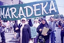
Maradeka women in Human Rights Action
After decades of “low intensity conflict” in Maguindanao between 1976 and 2000, President Estrada’s “All Out War” strategy declared in 2000 led to the displacement of more than 930,000 individuals. The decade that followed has been marked by a cycle of violence and resumption of peace talks between the government and the Moro Islamic Liberation Front that sought to establish an independent Islamic state in Maguindanao. The fighting led to several periods of mass population displacement at the very latest even until the term of President Gloria Macapagal Arroyo displacing another 150,000 individuals mostly of Moro & Lumad communities[13]
Between 2000 and 2010, four out of ten households (41%) reported having experienced displacement: 29% reported displacement caused by armed groups’ movements, 9% identified ridos (blood feuds), and 9% identified other causes, such as economic displacement (3%) or natural disasters (2%). Armed groups’ movements were by far the most frequent cause of displacement and also the most damageable. Some provinces were more affected than others, mostly of the Moro as they are the most active in resistance to what they perceived to be an extension of Spanish colonialism now perpetuated by the hands of the Philippine Government. Areas that suffered most damage and displacement are Maguindanao (82%), Lanao del Norte (48%) and Lanao del Sur (47%). Other forms of violence have also been prevalent. For example, in Maguindanao, 45% of the total population reported the destruction of their home. Other forms of violence reported in that province include the destruction of goods (37%), being attacked by someone with a weapon (20%), witness looting (32%), and witness killing (16%).[14]
Political divisions
Main article: Political divisions of Mindanao

The six regions are:
| Administrative region | Area (km²) | Population (2010 census)[1] |
Population density (/km²) |
|---|---|---|---|
| Zamboanga Peninsula | 16,823 | 3,407,353 | 202.54 |
| Northern Mindanao | 20,132 | 4,297,323 | 213.50 |
| Davao Region | 20,244 | 4,468,563 | 220.74 |
| SOCCSKSARGEN | 22,466 | 4,109,571 | 182.92 |
| Caraga | 21,471 | 2,429,224 | 113.14 |
| ARMM | 26,974 | 3,256,140 | 120.71 |
| Mindanao group | 128,110 | 21,968,174 | 171.5 |
As for representation in the Philippine Congress, Mindanao is represented by 46 congressmen elected in the same manner as the governors.
Zamboanga Peninsula (Region 9)
Zamboanga Peninsula, located in Western Mindanao, is an administrative region located in the Philippines. The regional center is Pagadian City. Isabela City, which is the capital of ARMM and geographically the part of Basilan, but it is an enclave of Zamboanga Peninsula. The provinces and independent cities are:- Isabela City (on Basilan Island)
- Zamboanga del Norte
- Zamboanga del Sur with Zamboanga City
- Zamboanga Sibugay
Northern Mindanao (Region 10)
Northern Mindanao is an all occupying the north-central part of Mindanao island, and the island-province of Camiguin. The regional center is Cagayan de Oro City. The provinces and cities are:- Bukidnon
- Camiguin (on Camiguin Island)
- Lanao del Norte with Iligan City
- Misamis Occidental
- Misamis Oriental with Cagayan de Oro City
Davao Region (Region 11)
Davao Region / Southern Mindanao is one of the regions of the Philippines, located on the southeastern portion of Mindanao. The regional center is Davao City. Its provinces are:SOCCSKSARGEN Region (Region 12)
SOCCSKSARGEN is a region of the Philippines, located in central Mindanao. The regional center is Koronadal City. Cotabato City is a part of Maguindanao, but a part of SOCCKSARGEN. The name is an acronym that stands for the region's four provinces and one of its cities:- South Cotabato with General Santos City and Koronadal City
- Cotabato
- Sultan Kudarat
- Cotabato City is a part of Maguindanao but a part of SOCCKSARGEN Region
- Sarangani
Caraga Region (Region 13)
Caraga is an administrative region of the Philippines, on the northeastern portion of the island of Mindanao. The regional center is Butuan City. Its provinces are:- Agusan del Norte with Butuan City
- Agusan del Sur
- Surigao del Norte with Surigao City
- Surigao del Sur
- Dinagat Islands (not on Mindanao Island)
Autonomous Region in Muslim Mindanao (ARMM)

Mosque in Basilan
- Basilan except Isabela (not on Mindanao Island)
- Lanao del Sur
- Maguindanao except Cotabato
- Sulu (not on Mindanao Island)
- Tawi-Tawi (not on Mindanao Island)
See also
- Mindanao Development Authority
- Caesarea Karoli
- Geography of the Philippines
- Rido, blood feuds
- Bangsamoro Republik
- Moro people
- Islam in the Philippines
- Lumad
- Majapahit
- Srivijaya
- Sultanate of Sulu
- Sultanate of Maguindanao
- Regions of the Philippines
- Provinces of the Philippines
- 2006 Central Mindanao bombings
- July 2009 Mindanao bombings
References
- "Population and Annual Growth Rates for The Philippines and Its Regions, Provinces, and Highly Urbanized Cities". 2010 Census and Housing Population. National Statistics Office. Retrieved 15 August 2014.
- Calderon, Justin (22 April 2013). "Unearthed gem". Inside Investor. Retrieved 29 April 2013.
- Subanon Territories "The History of Subanon since the Neolithic Era or Stone Age". Retrieved 2013-11-08.
- Koerner, Brendan I. (28 January 2005). "How Islam got to the Philippines". Slate. Retrieved 4 October 2009.
- Childress, C., 2003, Wendell Fertig's Fictional "Autobiography": a Critical Review of They Fought Alone, Bulletin of the American Historical Collection, Vol. 31, No. 1 (123)
- "Islam and the Politics of Identity". University of Hawaii – Center for Philippine Studies.
- C.Michael Hogan. 2011. Sulu Sea. Encyclopedia of Earth. Eds. P. Saundry & C.J.Cleveland. Washington DC
- ISSUU - Land Tenure Stories in Central Mindanao by Local Governance Support Program in ARMM
- "Mindanao Comprised About 24 Percent of the Philippines' Total Population". Philippine Statistics Authority. 8 June 2005.
- Calderon, Justin (12 March 2013). "Mindanao to face higher power prices". Inside Investor. Retrieved 13 March 2013.
- "Mindanao power problem close to solution". Investvine. 30 January 2013. Retrieved 11 February 2013.
- General Santos
- Norwegian Refugee Council (2009). Cycle of conflict and neglect: Mindanao’s displacement and protection crisis.
- Vinck P, Bell E (2011). Violent Conflicts and Displacement in Central Mindanao: Challenges for recovery and development. world Bank and world Food Programme.
- List of Regions in the Philippines
External links
| Wikimedia Commons has media related to Mindanao. |
| Look up mindanao in Wiktionary, the free dictionary. |
- information on conflict affected area
- Violent Conflicts and Displacement in Central Mindanao: Challenges for recovery and development
- Mindanao Magazine[dead link]
- Mindanao Magazine[dead link]
- Moro Friends Community
- The Catalyst for Countryside Development
- Mindanao News
- Online Mindanao
- Taboan Mindanao
|
||
|
||
|
|||
